Coral Bleaching: Toolkit & Comprehensive Guide
Remote Sensing Tools
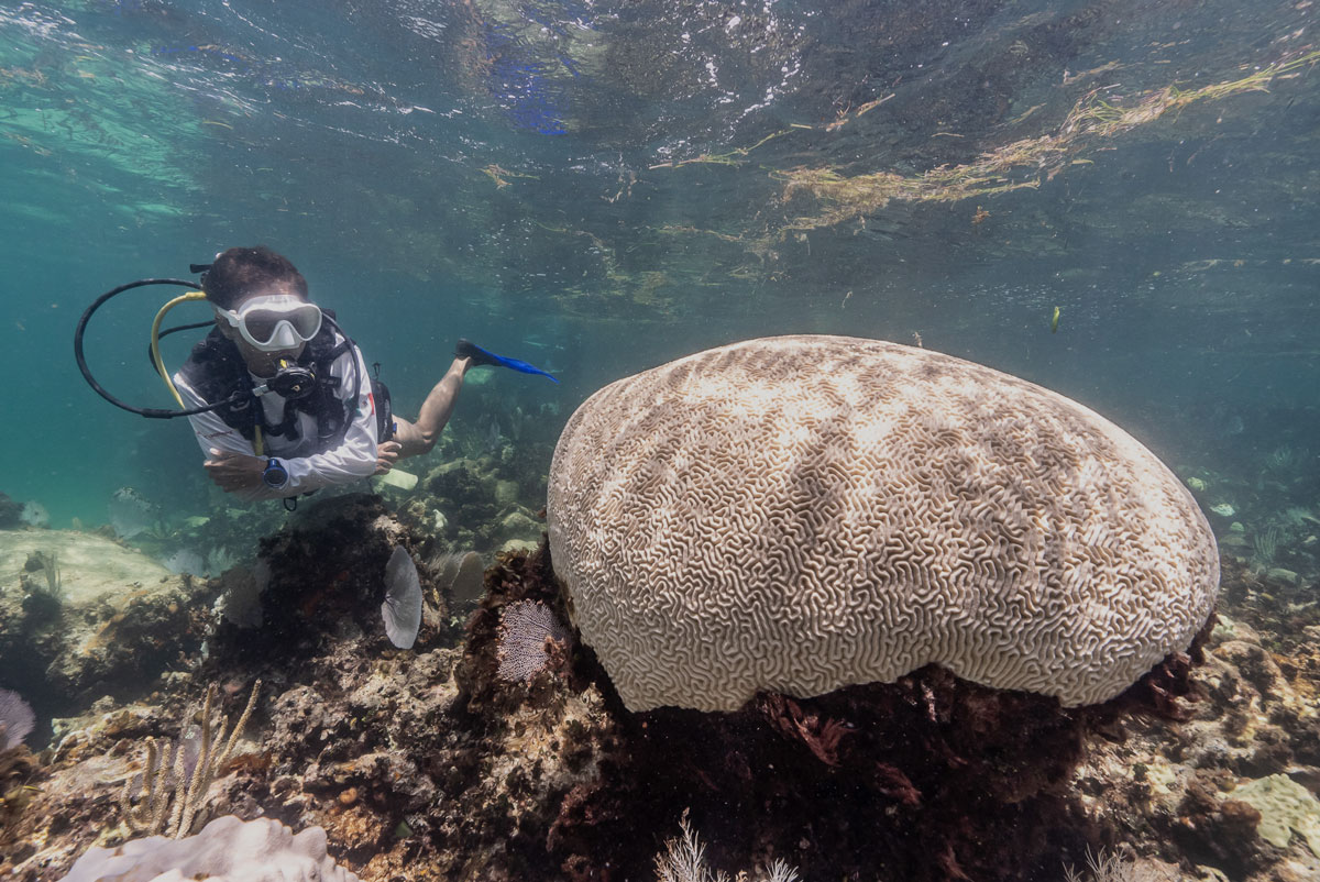
Photo by Valentina Cucchiara, CORAL
Keep an Eye on Coral Bleaching from Afar
Many programs and initiatives play a vital role in increasing our understanding of coral bleaching events across the globe. These efforts help to inform conservation and management strategies aimed at protecting these valuable marine ecosystems. Coral bleaching monitoring involves various methods that range from remote sensing tools using satellite data to others that rely upon on-site observations, underwater photography, or coral tissue sampling by scuba divers. In this section, we’ll cover some of the available early warning remote sensing tools used to track global or regional coral bleaching events.
NOAA Coral Reef Watch
The National Oceanic and Atmospheric Administration (NOAA) Coral Reef Watch (CRW) program provides the most widely used global early-warning system of coral reef ecosystem environmental changes.
Coral reef stakeholders worldwide apply NOAA CRW’s modeled Outlook and satellite-based products to predict and monitor in near real-time the thermal stress that drives coral bleaching, disease, and death. CRW products are primarily sea surface temperature (SST)-based but also incorporate light and ocean color data, among other variables. CRW offers an automated Satellite Bleaching Alert (SBA) email system that alerts subscribers to heat stress conducive to coral bleaching at reef locations around the globe. The SBA system, which is based on CRW’s daily global 5km-resolution satellite coral bleaching heat stress monitoring products, automatically delivers up-to-date information on changes in the bleaching alert status for those reefs, to which a user subscribes. It allows critical information about coral bleaching heat stress to reach a user immediately, without requiring the user to check the CRW website. Sign up for NOAA email alerts here!
Additional resources:
NOAA CRW Outreach
NOAA Coral Reef Conservation Program
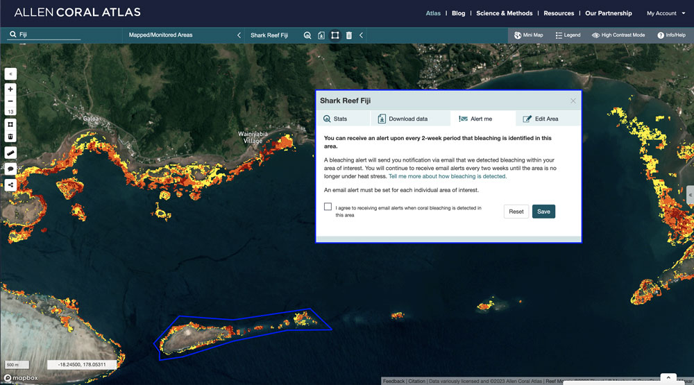
Allen Coral Atlas
The Allen Coral Atlas partnership uses high-resolution satellite imagery (Planet Dove), machine learning, and field data to map and monitor the world’s coral reefs at unprecedented global coverage. The Atlas provides the new dynamic “Reef Threats” monitoring technology, along with the first comprehensive map of benthic habitats and reef geomorphology. Reef Threats was developed by Arizona State University’s (ASU) Center for Global Discovery and Conservation Science and provides tracking of the location, extent, and severity of potential coral reef bleaching and changes in ocean water turbidity worldwide. The Atlas also has a new bleaching alert system available for marine regions of the world (economic exclusive zones for each country), marine protected areas, or specific areas of interest. The monitoring system provides observation of potential coral bleaching in three levels of severity (low, moderate, severe) at 10m resolution, based on Sentinel-2 satellite monitoring and incorporating NOAA Coral Reef Watch product data. Sign up for bleaching alerts here!
Additional resources:
Blog New Alert: Global Tracking of Coral Bleaching Events
Reef Resilience Network course: Remote Sensing and Mapping for Coral Reef Conservation available in English, Spanish, Bahasa, and French.
Coastal Marine Information and Analysis System
(English translation of Sistema de Información Análisis Marino Costera, SIMAR), led by Comisión Nacional para el Conocimiento y Uso de la Biodiversidad (CONABIO)-México. SIMAR integrates, analyses, manages, and visualizes large volumes of multi-scale data derived from in-situ sampling and monitoring physical and chemical parameters, biodiversity records and citizen science, satellite observations of ocean temperature and color, climate models, and geospatial information. SIMAR provides an operational early warning system for coral bleaching, pelagic sargassum, and red tides in the Caribbean.
Additional resource: Video
Western Indian Ocean Coral Bleaching Monitoring Service
The Marine and Coastal Operations for Southern Africa (MarCOSouth) project is one of four projects under the marine and coastal thematic areas within the Global Monitoring for Environment and Security (GMES) and Africa program. The WIO Coral Bleaching Monitoring Service provides satellite-derived risk and monitoring products for coastal and nearshore ecosystems that are high-value, ecologically vulnerable natural capital or exploitable resources. The service was co-designed by earth observation researchers and developers from the Council for Scientific and Industrial Research (CSIR) in collaboration with domain experts and consortium partners from Coastal Oceans Research and Development – Indian Ocean (CORDIO) East Africa.
Additional resources: Video
Hawaii and US Pacific Islands Region Climate Impacts and Outlook
The quarterly outlook draws on the Pacific El Nino-Southern Oscillation (ENSO) Applications Climate Services Climate Center’s (PEAC) “Pacific ENSO Update” quarterly newsletter and other sources to bring together seasonal predictions and projections alongside information on recent impacts of weather and climate events in a concise and accessible format. This webpage also provides access to information used to develop the quarterly outlook as a “dashboard” that aggregates climate variability-related content via links to products and information from a mix of primarily US agencies, institutions, and organizations.
Aqualink
Aqualink is a philanthropic engineering organization working on building ocean conservation technology. It’s a real-time global ocean temperature monitoring platform that allows users to create sites of interest to virtually track heat stress or via deployed solar-powered Aqualink Smart Buoys by Sofar. Advanced features include live streams and additional instrumentation that measure water quality parameters or temperature tracking using temperature loggers.
The Coral Bleaching Alert System
The Coral Bleaching Alert System (CBAS) was launched in 2011 by the Indian National Centre for Ocean Information Services (INCOIS) a unit of the Earth System Science Organization (ESSO) under the Ministry of Earth Sciences, Govt. of India. The CBAS utilizes satellite-derived Sea Surface Temperature (SST) data to evaluate thermal stress levels affecting coral reefs in the Andaman, Gulf of Kutch, Gulf of Mannar, and Nicobar regions. This approach helps identify initial indicators of coral bleaching intensity and spatial distribution. Adapted from NOAA’s reef monitoring methods and validated against past bleaching events in Indian coral regions, CBAS provides updates every three days, including Hotspot, Degree of Heating Weeks, and time series data products.
Additional Information
Resource Watch, contains an interactive dashboard with past bleaching events in the world.